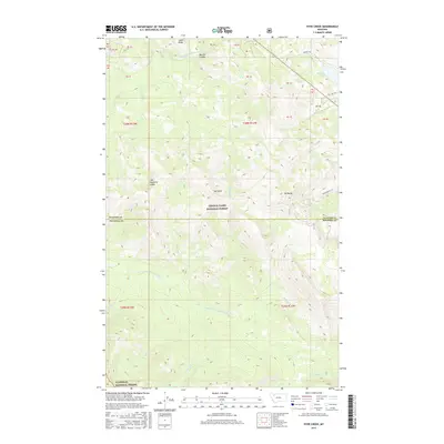
2017 Map of Hyde Creek
USGS Topo · Published 2017About this map
Lewis & Clark National Forest and Flathead National Forest dominate this high-altitude landscape along the Continental Divide. The complex topography is anchored by prominent summits like Mt Pablo and Mt Baldy, with the massive forms of Two Medicine Ridge and Lubec Ridge defining the drainage patterns. This map documents a critical hydrologic intersection where headwaters such as the S Fork Two Medicine River and the N Badger Cr originate. The network of backcountry routes, including the humorously named Palookaville Trl and the remote Hughes Trl, illustrates the historical access points into this wilderness. Waters collected at Dog Gun Lake and various coulees, like Mettler Coulee, feed the intricate stream systems that carve through the mountain passes, highlighting the area's role as a primary watershed for the region.
Find a feature on this map
32 named features on this map. Tap any name to fly to it.
Don’t see what you’re looking for? This feature index may not catch every label — zoom into the map to look around manually.
Map Details
Editions of this 2017 Hyde Creek Map
This is the sole edition of this map. No revisions or reprints were ever made.
Other maps of this area

1913 · Marias Pass
USGS Topo · 1:125,000

1958 · Red Plume Mountain
USGS Topo · 1:24,000

1958 · Crescent Cliff
USGS Topo · 1:24,000

1960 · Cut Bank
USGS Topo · 1:250,000

1963 · Cut Bank
USGS Topo · 1:250,000

1964 · Cut Bank
USGS Topo · 1:250,000

1968 · Half Dome Crag
USGS Topo · 1:24,000
1968 · Morningstar Mountain
USGS Topo · 1:24,000
1968 · East Glacier Park
USGS Topo · 1:24,000
1968 · Squaw Mountain
USGS Topo · 1:24,000