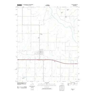
2009 Map of Hydro
USGS Topo · Published 2009About this map
The town of Hydro serves as the central hub of this agricultural and transit landscape, where the legacy of the Mother Road remains visible via Old US Hwy 66. This corridor follows the drainage patterns of Deer Creek and Dead Woman Creek, illustrating how historic transportation routes often paralleled local waterways. To the north, the terrain is shaped by the winding Canadian River and geological features such as American Horse Canyon and Cedar Canyon, which contrast with the orderly grid of section roads like e0990 RD and n2480 RD.
Find a feature on this map
34 named features on this map. Tap any name to fly to it.
Don’t see what you’re looking for? This feature index may not catch every label — zoom into the map to look around manually.
Map Details
Editions of this 2009 Hydro Map
This is the sole edition of this map. No revisions or reprints were ever made.
Other maps of this area

1942 · Geary
USGS Topo · 1:62,500

1951 · Binger
USGS Topo · 1:62,500

1955 · Clinton
USGS Topo · 1:250,000

1957 · Clinton
USGS Topo · 1:250,000

1961 · Eakly
USGS Topo · 1:62,500

1964 · Weatherford
USGS Topo · 1:62,500

1979 · Greenfield
USGS Topo · 1:24,000
1979 · Rock Mary
USGS Topo · 1:24,000
1979 · Bridgeport
USGS Topo · 1:24,000
1984 · Eakly NE
USGS Topo · 1:24,000