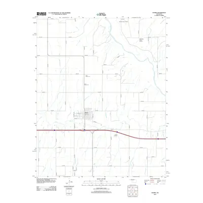
2012 Map of Hydro
USGS Topo · Published 2012About this map
Hydro serves as the central hub of this West-Central Oklahoma landscape, situated where the high plains meet the intricate drainage systems of the Canadian River. The settlement is defined by a traditional grid of streets like W Main St and E 5th St, reflecting its role as a local center for commerce and agriculture. To the north, the town's history is anchored by the Hydro Masonic Cem and Hydro Catholic Cem, providing essential markers for genealogical research in Caddo County.
Find a feature on this map
39 named features on this map. Tap any name to fly to it.
Don’t see what you’re looking for? This feature index may not catch every label — zoom into the map to look around manually.
Map Details
Editions of this 2012 Hydro Map
This is the sole edition of this map. No revisions or reprints were ever made.
Other maps of this area

1942 · Geary
USGS Topo · 1:62,500

1951 · Binger
USGS Topo · 1:62,500

1955 · Clinton
USGS Topo · 1:250,000

1957 · Clinton
USGS Topo · 1:250,000

1961 · Eakly
USGS Topo · 1:62,500

1964 · Weatherford
USGS Topo · 1:62,500

1979 · Greenfield
USGS Topo · 1:24,000
1979 · Rock Mary
USGS Topo · 1:24,000
1979 · Bridgeport
USGS Topo · 1:24,000
1984 · Eakly NE
USGS Topo · 1:24,000