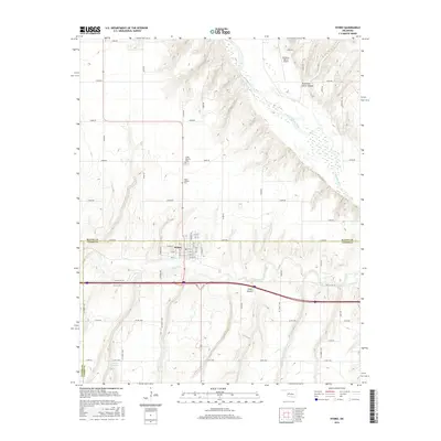
2016 Map of Hydro
USGS Topo · Published 2016About this map
The town of Hydro serves as the central hub of this landscape, situated near the intersection of the Blaine and Caddo county lines. This prairie environment is defined by the deep incisions of American Horse Canyon and Cedar Canyon, which break the level agricultural topography and drain toward the Canadian River to the east. The settlement patterns reflect a strictly gridded road system, though the presence of the McKinley Ranch Airport and the local 015015 Reservoir indicate a mix of ranching utility and modern infrastructure. Genealogists will find the locations of the Hydro Masonic Cem and Hydro Catholic Cem particularly notable, as these sites sit north of the main town site along the sectional roads. The drainage of Deer Cr further characterizes the local hydrology, illustrating how water management and natural terrain dictated the development of this rural Oklahoma community.
Find a feature on this map
56 named features on this map. Tap any name to fly to it.
Don’t see what you’re looking for? This feature index may not catch every label — zoom into the map to look around manually.
Map Details
Editions of this 2016 Hydro Map
This is the sole edition of this map. No revisions or reprints were ever made.
Other maps of this area

1942 · Geary
USGS Topo · 1:62,500

1951 · Binger
USGS Topo · 1:62,500

1955 · Clinton
USGS Topo · 1:250,000

1957 · Clinton
USGS Topo · 1:250,000

1961 · Eakly
USGS Topo · 1:62,500

1964 · Weatherford
USGS Topo · 1:62,500

1979 · Greenfield
USGS Topo · 1:24,000
1979 · Rock Mary
USGS Topo · 1:24,000
1979 · Bridgeport
USGS Topo · 1:24,000
1984 · Eakly NE
USGS Topo · 1:24,000