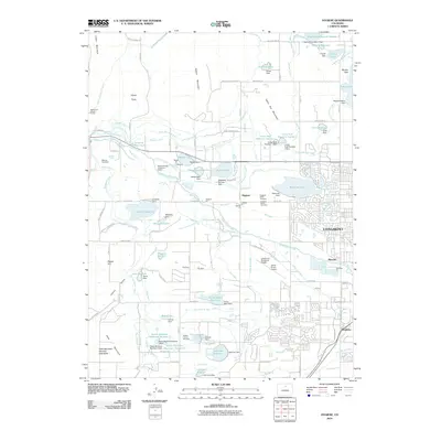
2010 Map of Hygiene
USGS Topo · Published 2010About this map
Hygiene sits at the heart of an intricate network of irrigation ditches and reservoirs that defines the agricultural landscape north of Longmont. This survey showcases the heavy reliance on surface water management in Boulder County, with numerous features like McIntosh Lake, Lagerman Reservoir, and the Oligarchy Number 1 Dam supporting the surrounding plains. The presence of the Ryssby Church and its accompanying Ryssby Cemetery highlights the Swedish heritage of the early settlement era, while several other cemeteries including Weisner Cemetery and Hygiene North Cemetery offer significant points of interest for local historians and genealogists.
Find a feature on this map
127 named features on this map. Tap any name to fly to it.
Don’t see what you’re looking for? This feature index may not catch every label — zoom into the map to look around manually.
Map Details
Editions of this 2010 Hygiene Map
This is the sole edition of this map. No revisions or reprints were ever made.
Other maps of this area

1902 · Boulder
USGS Topo · 1:62,500

1904 · Niwot
USGS Topo · 1:62,500

1904 · Boulder
USGS Topo · 1:62,500

1905 · Mount Olympus
USGS Topo · 1:62,500

1906 · Loveland
USGS Topo · 1:62,500

1907 · Mount Olympus
USGS Topo · 1:62,500

1908 · Loveland
USGS Topo · 1:62,500

1950 · Hygiene
USGS Topo · 1:24,000
1950 · Erie
USGS Topo · 1:24,000

1950 · Niwot
USGS Topo · 1:24,000