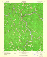
1964 Map of Iaeger
USGS Topo · Published 1965About this map
Iaeger sits at the confluence of the Tug Fork and Dry Fork, serving as a critical junction for the Norfolk and Western railroad during the mid-1960s. The landscape is defined by its deep winding valleys and the extensive extraction industry, with numerous mines, strip mines, and a gas well scattered across the ridgelines. The western portion of the quadrangle is dominated by the protected timberlands of Panther State Forest, where Hurricane Ridge and Sourwood Ridge form a natural barrier. In the more settled valleys, a complex network of small communities like Avondale, Litwar, and Beartown are linked by the rail lines and river bends. Family history is well-preserved through numerous small burial grounds such as Lockhart Cem and Meadows Cem, alongside local institutions like the Carlos Sch and a Drive-in Theater near Sandy Huff Branch.
Find a feature on this map
80 named features on this map. Tap any name to fly to it.
Don’t see what you’re looking for? This feature index may not catch every label — zoom into the map to look around manually.
Map Details
Editions of this 1964 Iaeger Map
3 editions found
Other maps of this area

1891 · Tazewell
USGS Topo · 1:125,000

1891 · Oceana
USGS Topo · 1:125,000

1893 · Oceana
USGS Topo · 1:125,000

1895 · Tazewell
USGS Topo · 1:125,000

1897 · Tazewell
USGS Topo · 1:125,000

1898 · Oceana
USGS Topo · 1:125,000

1909 · Gilbert
USGS Topo · 1:48,000

1910 · Pineville
USGS Topo · 1:48,000

1910 · Iaeger
USGS Topo · 1:48,000

1912 · Gilbert
USGS Topo · 1:62,500