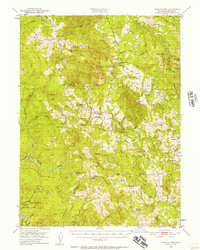
1950 Map of Iaqua Buttes
USGS Topo · Published 1957About this map
The remote ranching and timber landscapes of Humboldt County are defined by the winding course of the Mad River and the complex drainage systems of Yager Creek and its many forks. In the early 1950s, this area was a network of family-held properties such as the Iaqua Ranch, Shaws Ranch, and the Harville Ranch, reflecting the region's agricultural roots. The presence of the Iaqua School (Aband) near the Iaqua Buttes points to a shifting population as smaller rural districts consolidated or vanished. High ridges like Barry Ridge and Ashfield Ridge provided the primary corridors for travel, connecting isolated outposts like Kneeland P. O. to the broader county. The map also identifies scattered Mines and significant landmarks like the Redwood House, offering a detailed view of the infrastructure supporting life in the Six Rivers National Forest during the mid-century.
Find a feature on this map
106 named features on this map. Tap any name to fly to it.
Don’t see what you’re looking for? This feature index may not catch every label — zoom into the map to look around manually.
Map Details
Editions of this 1950 Iaqua Buttes Map
3 editions found

Other maps of this area

1914 · Pilot Creek
USGS Topo · 1:62,500

1915 · Big Bar and Vicinity
USGS Topo · 1:250,000

1919 · Glynn
USGS Topo · 1:62,500

1921 · Dyerville
USGS Topo · 1:62,500

1922 · Eureka
USGS Topo · 1:62,500

1922 · Korbel
USGS Topo · 1:62,500

1922 · China Flat
USGS Topo · 1:62,500

1922 · Kneeland
USGS Topo · 1:62,500

1933 · Eureka
USGS Topo · 1:48,000

1942 · Eureka
USGS Topo · 1:62,500