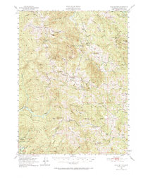
1950 Map of Iaqua Buttes
USGS Topo · Published 1966About this map
Iaqua Buttes dominate the central terrain of this Humboldt County survey, providing a detailed view of the remote ranching and timber landscapes of the northern Coast Ranges. The map illustrates a network of isolated homesteads and working ranches, such as Mtn View Ranch, Iaqua Ranch, and the Redwood House, connected by rugged ridges and river canyons. The educational history of these scattered mountain communities is documented through the locations of the Kneeland Sch, Showers Pass Sch, and the already Iaqua School (Aband).
Find a feature on this map
69 named features on this map. Tap any name to fly to it.
Don’t see what you’re looking for? This feature index may not catch every label — zoom into the map to look around manually.
Map Details
Editions of this 1950 Iaqua Buttes Map
3 editions found

Other maps of this area

1914 · Pilot Creek
USGS Topo · 1:62,500

1915 · Big Bar and Vicinity
USGS Topo · 1:250,000

1919 · Glynn
USGS Topo · 1:62,500

1921 · Dyerville
USGS Topo · 1:62,500

1922 · Eureka
USGS Topo · 1:62,500

1922 · Korbel
USGS Topo · 1:62,500

1922 · China Flat
USGS Topo · 1:62,500

1922 · Kneeland
USGS Topo · 1:62,500

1933 · Eureka
USGS Topo · 1:48,000

1942 · Eureka
USGS Topo · 1:62,500