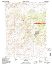
1992 Map of Ice Cave Mountain
USGS Topo · Published 1996About this map
Ice Cave Mountain and the surrounding heights of the Deer Creek Range dominate this 1990s U.S. Forest Service and USGS study of Natrona County. The landscape is defined by a network of drainage systems, including the West Fork Deer Creek to the north and Bates Creek to the southwest. Human presence is sparse and localized, represented by the isolated Miles Cabin and several unmarked Ruins situated within the Medicine Bow National Forest.
Find a feature on this map
19 named features on this map. Tap any name to fly to it.
Don’t see what you’re looking for? This feature index may not catch every label — zoom into the map to look around manually.
Map Details
Editions of this 1992 Ice Cave Mountain Map
This is the sole edition of this map. No revisions or reprints were ever made.
Other maps of this area

1955 · Casper
USGS Topo · 1:250,000

1958 · Casper
USGS Topo · 1:250,000

1959 · Squaw Spring
USGS Topo · 1:24,000

1959 · Bates Creek Reservoir
USGS Topo · 1:24,000

1960 · Crimson Dawn
USGS Topo · 1:24,000

1960 · Sheep Creek
USGS Topo · 1:24,000

1960 · Mud Springs
USGS Topo · 1:24,000

1960 · Ice Cave Mountain
USGS Topo · 1:24,000

1960 · Banner Mtn
USGS Topo · 1:24,000
1960 · Otter Creek
USGS Topo · 1:24,000