
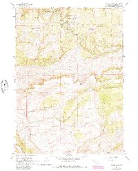
1960 Map of Crimson Dawn
USGS Topo · Published 1964About this map
Casper Mountain and Muddy Mountain dominate this mid-century survey of the high country south of Casper, Wyoming. The terrain is defined by a series of recreation sites and early mountain retreats, including the Hogadon Basin Ski Area and the Beartrap Meadow County Park. The settlement of Crimson Dawn sits at the edge of the plateau, while the map preserves the location of Eadsville (Site), an old mining camp. Numerous organizational camps, such as Camp Sacajawea and the Casper Lions Camp, are clustered along the ridge near Circle Drive. South of the mountain crest, the landscape transitions into a network of drainages like Garden Creek and Muddy Creek, where ranching life is noted by the remote Cheney Cow Camp.
Find a feature on this map
32 named features on this map. Tap any name to fly to it.
Don’t see what you’re looking for? This feature index may not catch every label — zoom into the map to look around manually.
Map Details
Editions of this 1960 Crimson Dawn Map
2 editions found
Other maps of this area

1949 · Brookhurst
USGS Topo · 1:24,000

1950 · Brookhurst
USGS Topo · 1:24,000

1950 · Goose Egg
USGS Topo · 1:24,000

1951 · Casper
USGS Topo · 1:24,000

1955 · Casper
USGS Topo · 1:250,000

1958 · Casper
USGS Topo · 1:250,000

1960 · Twin Buttes
USGS Topo · 1:24,000

1960 · Sheep Creek
USGS Topo · 1:24,000

1960 · Ice Cave Mountain
USGS Topo · 1:24,000
1960 · Freeland
USGS Topo · 1:24,000