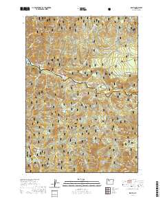
2020 Map of Idanha
USGS Topo · Published 2020About this map
The North Santiam River carves through this portion of the Willamette National Forest, defining the geography between Marion and Linn counties. The settlement of Idanha and the nearby area of New Idanha are situated along the riverbanks, where the topography transitions from the water's edge to significant elevations like Hoover Ridge and Coopers Ridge. This 2020 survey illustrates a landscape dominated by water and timber management, with unique features such as the Idanha Bog Pond and several high-altitude water bodies including Rainbow Lake, Bear Lake, and the Bruno Lakes.
Find a feature on this map
52 named features on this map. Tap any name to fly to it.
Don’t see what you’re looking for? This feature index may not catch every label — zoom into the map to look around manually.
Map Details
Editions of this 2020 Idanha Map
This is the sole edition of this map. No revisions or reprints were ever made.
Other maps of this area

1927 · Mt. Jefferson
USGS Topo · 1:125,000

1929 · Mill City
USGS Topo · 1:125,000

1930 · Mt. Jefferson
USGS Topo · 1:125,000

1953 · Salem
USGS Topo · 1:250,000

1954 · Salem
USGS Topo · 1:250,000

1955 · Bend
USGS Topo · 1:250,000

1956 · Battle Ax
USGS Topo · 1:62,500

1956 · Detroit
USGS Topo · 1:62,500

1957 · Bend
USGS Topo · 1:250,000

1958 · Bend
USGS Topo · 1:250,000