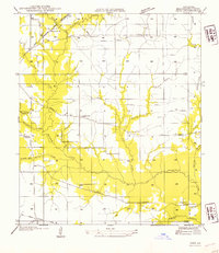
1954 Map of Ikes
USGS Topo · Published 1954About this map
Bundick Creek and its many tributaries, including Deer Creek and Brushy Creek, dominate this landscape in central Beauregard Parish. The drainage patterns shown reveal a territory defined by wetlands and creek hollows, such as Turkey Hollow and Hickory Hollow. Historically, this area was deeply influenced by the timber industry, evidenced by the extensive Old Logging Railroad Grade that winds through the northern and southern sections. Rural life is anchored by small community centers and religious landmarks, including the Community Club and churches like Pleasant Hill Ch and Pleasant Home Ch. The Gulf and Colorado Santa Fe railroad line cuts across the northwest corner near Ikes, while U S Highway No 190 provides the primary east-west corridor for the region during the mid-20th century.
Find a feature on this map
27 named features on this map. Tap any name to fly to it.
Don’t see what you’re looking for? This feature index may not catch every label — zoom into the map to look around manually.
Map Details
Editions of this 1954 Ikes Map
This is the sole edition of this map. No revisions or reprints were ever made.
Other maps of this area

1947 · DeRidder
USGS Topo · 1:31,680

1947 · Rosepine
USGS Topo · 1:31,680

1947 · Ikes
USGS Topo · 1:31,680

1947 · Chasmore
USGS Topo · 1:31,680

1947 · Bundick
USGS Topo · 1:31,680

1947 · Beckwith School
USGS Topo · 1:31,680

1947 · Sugartown
USGS Topo · 1:31,680

1947 · Bannister
USGS Topo · 1:31,680

1947 · Sugrue
USGS Topo · 1:31,680
1950 · Dry Creek
USGS Topo · 1:24,000