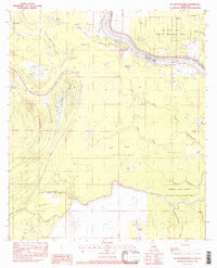
1982 Map of Ile Natchitoches
USGS Topo · Published 1983About this map
Ile Natchitoches and the surrounding alluvial lowlands of Avoyelles Parish are defined by an intricate network of waterways and managed wetlands. The Red River flows along the northern edge of the map, forming the border with Concordia Parish and feeding into a complex system of bayous and lakes. The landscape is dominated by dense hydrology, from the broad Lac Long and Natchitoches Bayou to the aptly named Dismal Swamp and Marais à Roche.
Find a feature on this map
37 named features on this map. Tap any name to fly to it.
Don’t see what you’re looking for? This feature index may not catch every label — zoom into the map to look around manually.
Map Details
Editions of this 1982 Ile Natchitoches Map
This is the sole edition of this map. No revisions or reprints were ever made.
Other maps of this area

1935 · Tooleys
USGS Topo · 1:62,500

1939 · Artonish
USGS Topo · 1:62,500

1939 · Deer Park
USGS Topo · 1:62,500

1941 · Voorhies
USGS Topo · 1:62,500

1941 · Tooleys
USGS Topo · 1:62,500

1953 · Natchez
USGS Topo · 1:250,000

1954 · Artonish
USGS Topo · 1:62,500

1955 · Artonish
USGS Topo · 1:62,500

1956 · Natchez
USGS Topo · 1:250,000

1958 · Artonish
USGS Topo · 1:62,500