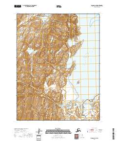
2018 Map of Iliamna A-4 SE
USGS Topo · Published 2018About this map
Katmai National Park and the Alaska Maritime National Wildlife Refuge converge on this remote Alaskan coastline, where protected wilderness meets the Pacific Ocean. The coastal geography is defined by deep indentations like Akunwarvik Bay, Pinkidulia Cove, and Horseshoe Cove, providing shelter beneath the elevation of McNeil Head. Freshwater systems including the McNeil River and Mikfik Cr drain into these saltwater inlets, creating a complex habitat for marine and terrestrial life. In the southern portion of the sheet, the Kamishak River and Little Kamishak River wind through the marshy lowlands, illustrating the drainage patterns that define the Kenai Peninsula's western shores. This map details a landscape where administrative boundaries of national conservation areas intersect with the wild, unpopulated terrain of the Pacific coast.
Find a feature on this map
17 named features on this map. Tap any name to fly to it.
Don’t see what you’re looking for? This feature index may not catch every label — zoom into the map to look around manually.
Map Details
Editions of this 2018 Iliamna A-4 SE Map
This is the sole edition of this map. No revisions or reprints were ever made.
Other maps of this area

1948 · Mt Katmai
USGS Topo · 1:250,000

1951 · Mt Katmai
USGS Topo · 1:250,000

1951 · Iliamna A-4
USGS Topo · 1:63,360

1951 · Mount Katmai D-1
USGS Topo · 1:63,360

1951 · Iliamna A-3
USGS Topo · 1:63,360

1952 · Iliamna
USGS Topo · 1:250,000

1952 · Iliamna A-4
USGS Topo · 1:63,360
1953 · Mount Katmai D-1
USGS Topo · 1:63,360

1957 · Iliamna
USGS Topo · 1:250,000

1964 · Mt. Katmai
USGS Topo · 1:250,000