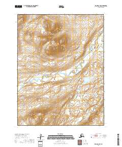
2018 Map of Iliamna A-4 SW
USGS Topo · Published 2018About this map
McNeil River flows across this coastal expanse of the Kenai Peninsula borough, illustrating a landscape defined by glacial drainages and dramatic elevation changes. The survey captures a transition from high peaks in the north, where Sulukpuk Cr originates, down to the low-lying southern plains marked by the meandering Little Kamishak River. This area is characterized by the absence of permanent human settlements or infrastructure, highlighting the primitive state of the terrain as it existed in 2018. The topographic contours reveal a complex system of ridges and valleys within the boundaries of t12s r31w and t13s r31w, providing a detailed look at the hydrology of these remote watersheds before they reach the sea.
Find a feature on this map
7 named features on this map. Tap any name to fly to it.
Don’t see what you’re looking for? This feature index may not catch every label — zoom into the map to look around manually.
Map Details
Editions of this 2018 Iliamna A-4 SW Map
This is the sole edition of this map. No revisions or reprints were ever made.
Other maps of this area

1948 · Mt Katmai
USGS Topo · 1:250,000

1951 · Mt Katmai
USGS Topo · 1:250,000

1951 · Iliamna A-5
USGS Topo · 1:63,360

1951 · Iliamna A-4
USGS Topo · 1:63,360

1951 · Mount Katmai D-1
USGS Topo · 1:63,360

1951 · Mount Katmai D-2
USGS Topo · 1:63,360

1952 · Iliamna
USGS Topo · 1:250,000

1952 · Iliamna A-4
USGS Topo · 1:63,360

1952 · Iliamna A-5
USGS Topo · 1:63,360
1953 · Mount Katmai D-1
USGS Topo · 1:63,360