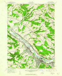
1943 Map of Ilion
USGS Topo · Published 1960About this map
Frankfort and Ilion serve as the industrial anchors of this valley landscape during the Second World War. The corridor is dominated by the parallel alignment of the New York State Barge Canal, the Mohawk River, and the New York Central Railroad, reflecting a transportation network designed for heavy transit through the Mohawk Valley. Outside these dense riverside settlements, the terrain rises into several named summits including Hasenclever Hill, Osborne Hill, and Steuben Hill, where a more rural way of life persisted in the mid-1940s.
Find a feature on this map
52 named features on this map. Tap any name to fly to it.
Don’t see what you’re looking for? This feature index may not catch every label — zoom into the map to look around manually.
Map Details
Editions of this 1943 Ilion Map
This is the sole edition of this map. No revisions or reprints were ever made.
Other maps of this area

1898 · Utica
USGS Topo · 1:62,500

1900 · Little Falls
USGS Topo · 1:62,500

1900 · Utica
USGS Topo · 1:62,500

1903 · Richfield Springs
USGS Topo · 1:62,500

1903 · Little Falls
USGS Topo · 1:62,500

1907 · Winfield
USGS Topo · 1:62,500

1939 · Little Falls
USGS Topo · 1:62,500

1943 · Newport
USGS Topo · 1:24,000

1943 · Utica East
USGS Topo · 1:24,000

1943 · Jordanville
USGS Topo · 1:24,000