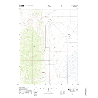
2018 Map of Illipah
USGS Topo · Published 2018About this map
Old Lincoln Hwy cuts across the northern desert landscape of White Pine County, tracing a historic path through this high-elevation corridor. The eastern slopes of the White Pine Range and the prominent Moorman Ridge define the western topography, where the Humboldt National Forest boundary protects the upland terrain. This area serves as a critical water source in an arid basin, evidenced by Moorman Spring and the drainage of Illipah Cr. To the east, the map transitions into the broad expanse of Jakes Valley, a region marked by seasonal water features like Jakes Pond and Cottonwood Pond. The presence of the Morman Ridge Trail suggests a landscape utilized for both transit and resource management, maintaining the footprint of early western travel routes well into the modern era.
Find a feature on this map
15 named features on this map. Tap any name to fly to it.
Don’t see what you’re looking for? This feature index may not catch every label — zoom into the map to look around manually.
Map Details
Editions of this 2018 Illipah Map
This is the sole edition of this map. No revisions or reprints were ever made.
Other maps of this area

1949 · Treasure Hill
USGS Topo · 1:62,500

1950 · Treasure Hill
USGS Topo · 1:62,500

1951 · Illipah
USGS Topo · 1:62,500

1956 · Ely
USGS Topo · 1:250,000

1959 · Ely
USGS Topo · 1:250,000

1959 · Reipetown
USGS Topo · 1:62,500

1959 · Preston Reservoir
USGS Topo · 1:62,500

1963 · Ely
USGS Topo · 1:250,000

1979 · Mt. Hamilton
USGS Topo · 1:100,000
1990 · Antelope Mountain
USGS Topo · 1:24,000