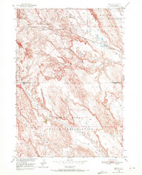
1950 Map of Imlay
USGS Topo · Published 1972About this map
The small railroad siding of Imlay serves as a lone point of habitation at the northern edge of the Pine Ridge Indian Reservation. This 1950 survey detail illustrates the stark geography where the Reservation Boundary divides the landscape of Shannon and Pennington counties. Running east-to-west, the Chicago Milwaukee St Paul and Pacific railroad tracks follow the natural contours north of the reservation, providing a vital transport link through this isolated territory.
Find a feature on this map
11 named features on this map. Tap any name to fly to it.
Don’t see what you’re looking for? This feature index may not catch every label — zoom into the map to look around manually.
Map Details
Editions of this 1950 Imlay Map
3 editions found
Other maps of this area

1950 · Sheep Mountain Table
USGS Topo · 1:24,000

1950 · Stirk Table
USGS Topo · 1:24,000

1950 · Imlay SW
USGS Topo · 1:24,000

1950 · Imlay
USGS Topo · 1:24,000

1950 · Imlay SE
USGS Topo · 1:24,000

1950 · Bouquet Table
USGS Topo · 1:24,000

1952 · Bouquet Table
USGS Topo · 1:24,000

1954 · Scenic
USGS Topo · 1:24,000

1955 · Hot Springs
USGS Topo · 1:250,000

1960 · Quinn Table SE
USGS Topo · 1:24,000