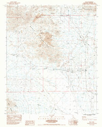
1983 Map of Inca
USGS Topo · Published 1983About this map
Mining and desert transportation dominate this California landscape, where the Big Maria Mountains and Mc Coy Mountains converge. The Atchison Topeka and Santa Fe railroad serves as the primary spine for local activity, supporting small outposts like the Inca (Siding) and the settlement of Midland. The extraction economy is clearly visible through several Open Pit Mine sites and established operations such as the Victor Mine and the Arlington Mine. These industrial hubs are connected by a network of desert routes, including Midland Road and Arlington Road, which navigate the complex system of the Dry Wash drainage that carves through the arid terrain. The presence of numerous benchmarks, such as BM m7 225.5 and BM 5 GWM 180.3, provides precise historical data points for surveyors and historians tracking the development of this desert corridor.
Find a feature on this map
24 named features on this map. Tap any name to fly to it.
Don’t see what you’re looking for? This feature index may not catch every label — zoom into the map to look around manually.
Map Details
Editions of this 1983 Inca Map
This is the sole edition of this map. No revisions or reprints were ever made.
Other maps of this area

1942 · Blythe
USGS Topo · 1:250,000

1945 · Big Maria Mtns
USGS Topo · 1:62,500

1945 · Midland
USGS Topo · 1:62,500

1951 · Big Maria Mts
USGS Topo · 1:62,500

1951 · McCoy Wash
USGS Topo · 1:24,000

1952 · Midland
USGS Topo · 1:62,500

1952 · Mc Coy Spring
USGS Topo · 1:62,500

1954 · Salton Sea
USGS Topo · 1:250,000

1955 · Salton Sea
USGS Topo · 1:250,000

1959 · Salton Sea
USGS Topo · 1:250,000