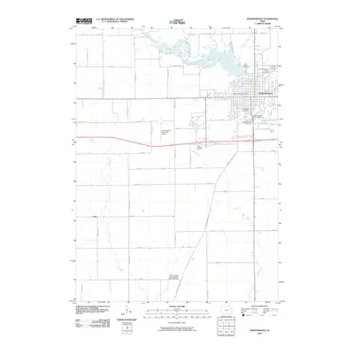
2010 Map of Independence
USGS Topo · Published 2010About this map
The Wapsipinicon River winds through the heart of Independence, serving as the primary geographic feature of this Buchanan County landscape. The city is a hub of civic and recreational activity, anchored by the Independence Post Office and the Buchanan County Fairgrounds, which sits adjacent to the Independence Motor Speedway. Several significant burial grounds are distributed across the area, including Saint Johns Cemetery, Oakwood Cemetery, and Mount Hope Cemetery, along with the State Hospital Cemetery located further west near the municipal complex.
Find a feature on this map
47 named features on this map. Tap any name to fly to it.
Don’t see what you’re looking for? This feature index may not catch every label — zoom into the map to look around manually.
Map Details
Editions of this 2010 Independence Map
This is the sole edition of this map. No revisions or reprints were ever made.
Other maps of this area

1901 · Oelwein
USGS Topo · 1:125,000

1903 · Winthrop
USGS Topo · 1:125,000

1954 · Waterloo
USGS Topo · 1:250,000

1955 · Waterloo
USGS Topo · 1:250,000

1959 · Dubuque
USGS Topo · 1:250,000

1961 · Dubuque
USGS Topo · 1:250,000

1962 · Dubuque
USGS Topo · 1:250,000
1971 · Brandon
USGS Topo · 1:24,000

1971 · Littleton
USGS Topo · 1:24,000
1971 · Jesup
USGS Topo · 1:24,000