1971 Map of Jesup
USGS Topo · Published 1973About this map
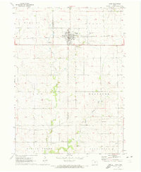
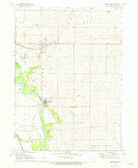
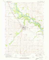
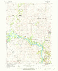
Jesup serves as the primary hub of this 1970s survey, straddling the county line between Black Hawk and Buchanan Counties. The town's grid is bisected by the Illinois Central railroad, a corridor that also features the St Athanasius Cem and Cedar Crest Cem. To the south, smaller rural nodes like Jubilee and Shady Grove provide evidence of earlier settlement patterns, linked by the winding course of Spring Creek and its East Branch. The landscape transition from town to countryside is marked by several private airfields, including Poyner Landing Strip and Collier Landing Strip, alongside traditional infrastructure like a Townhall in Fox Township. This survey documents the intersection of established midwestern agriculture with modern utility corridors, evidenced by the large Pipelines cutting across the southern prairie.
Find a feature on this map
25 named features on this map. Tap any name to fly to it.
Don’t see what you’re looking for? This feature index may not catch every label — zoom into the map to look around manually.
Map Details
Editions of this 1971 Jesup Map
This is the sole edition of this map. No revisions or reprints were ever made.
Other maps of this area

1901 · Oelwein
USGS Topo · 1:125,000

1903 · Winthrop
USGS Topo · 1:125,000

1954 · Waterloo
USGS Topo · 1:250,000

1955 · Waterloo
USGS Topo · 1:250,000

1959 · Dubuque
USGS Topo · 1:250,000

1961 · Dubuque
USGS Topo · 1:250,000

1962 · Dubuque
USGS Topo · 1:250,000
1971 · Gilbertville
USGS Topo · 1:24,000
1971 · La Porte City
USGS Topo · 1:24,000
1971 · Brandon
USGS Topo · 1:24,000