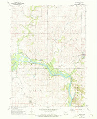
1971 Map of Brandon
USGS Topo · Published 1973About this map
The Cedar River dominates this landscape where Black Hawk, Buchanan, and Benton counties converge. In the early 1970s, the community of Brandon sits at the northeastern edge of the river's path, while Mt Auburn is positioned to the southwest along the Chicago Rock Island and Pacific railroad line. The map highlights the agricultural and transport infrastructure of the era, from the Mt Auburn Bridge to the various quarries and sewage disposal sites that supported local growth.
Find a feature on this map
25 named features on this map. Tap any name to fly to it.
Don’t see what you’re looking for? This feature index may not catch every label — zoom into the map to look around manually.
Map Details
Editions of this 1971 Brandon Map
2 editions found
Other maps of this area

1888 · Shellsburg
USGS Topo · 1:62,500

1889 · Shellsburg
USGS Topo · 1:62,500

1899 · Shellsburg
USGS Topo · 1:62,500

1903 · Winthrop
USGS Topo · 1:125,000

1954 · Waterloo
USGS Topo · 1:250,000

1955 · Waterloo
USGS Topo · 1:250,000

1959 · Dubuque
USGS Topo · 1:250,000

1961 · Dubuque
USGS Topo · 1:250,000

1962 · Dubuque
USGS Topo · 1:250,000
1968 · Center Point NW
USGS Topo · 1:24,000