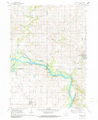
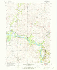
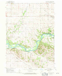
1971 Map of Brandon
USGS Topo · Published 1986About this map
The Cedar River carves a broad valley through this pocket of eastern Iowa, defining the boundary between Black Hawk, Buchanan, and Benton counties. Along its winding course, the landscape is dotted with riverfront recreational spaces like Minne Estema Park and Mt Auburn Bridge Park. The small community of Brandon sits at the eastern edge of the survey, where local industry is noted by a Sewage Disposal plant and a nearby Quarry. Further south, the town of Mt Auburn is positioned near the corridor of the Chicago Rock Island and Pacific railroad, which cuts through the agricultural terrain of Harrison and Cedar townships. Evidence of early settlement and rural life is preserved at the Spring Creek Cem, located near the East Branch of its namesake stream. The map captures an era of established small-town infrastructure and river-dependent geography.
Find a feature on this map
24 named features on this map. Tap any name to fly to it.
Don’t see what you’re looking for? This feature index may not catch every label — zoom into the map to look around manually.
Map Details
Editions of this 1971 Brandon Map
2 editions found
Other maps of this area

1888 · Shellsburg
USGS Topo · 1:62,500

1889 · Shellsburg
USGS Topo · 1:62,500

1899 · Shellsburg
USGS Topo · 1:62,500

1903 · Winthrop
USGS Topo · 1:125,000

1954 · Waterloo
USGS Topo · 1:250,000

1955 · Waterloo
USGS Topo · 1:250,000

1959 · Dubuque
USGS Topo · 1:250,000

1961 · Dubuque
USGS Topo · 1:250,000

1962 · Dubuque
USGS Topo · 1:250,000
1968 · Center Point NW
USGS Topo · 1:24,000