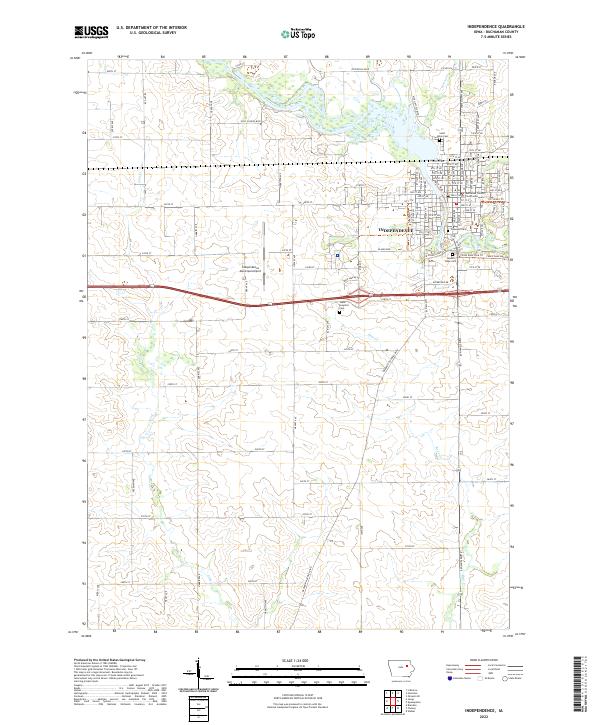
2022 Map of Independence
USGS Topo · Published 2022About this map
The Wapsipinicon River winds through the heart of Independence, serving as the primary geographic anchor for this section of Buchanan County. As the county seat, the city is defined by its civic and historical infrastructure, including the Buchanan County Courthouse and a collection of established burial grounds such as Oakwood Cem and Saint Johns Cem. The river's influence is evident in local recreation along the River Walk Trl and the presence of several tributary streams like Harter Cr and Lime Cr that drain the surrounding agricultural township lands. To the west of the urban center, the Independence Municipal Airport marks the transition toward more open rural sections. This modern survey also documents the State Hospital Cem and Hope Cem, providing essential points of reference for genealogists and local historians tracing the development of this river-centered Iowa community.
Find a feature on this map
84 named features on this map. Tap any name to fly to it.
Don’t see what you’re looking for? This feature index may not catch every label — zoom into the map to look around manually.
Map Details
Editions of this 2022 Independence Map
This is the sole edition of this map. No revisions or reprints were ever made.
Other maps of this area

1901 · Oelwein
USGS Topo · 1:125,000

1903 · Winthrop
USGS Topo · 1:125,000

1954 · Waterloo
USGS Topo · 1:250,000

1955 · Waterloo
USGS Topo · 1:250,000

1959 · Dubuque
USGS Topo · 1:250,000

1961 · Dubuque
USGS Topo · 1:250,000

1962 · Dubuque
USGS Topo · 1:250,000
1971 · Brandon
USGS Topo · 1:24,000

1971 · Littleton
USGS Topo · 1:24,000
1971 · Jesup
USGS Topo · 1:24,000