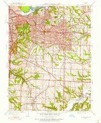
1934 Map of Independence
USGS Topo · Published 1955About this map
Independence serves as the focal point of this 1934 survey, shown during a period of significant growth and institutional expansion on the eastern edge of Kansas City. The landscape is defined by its deep connectivity to the regional rail network, with lines from the Missouri Pacific, Atchison Topeka and Santa Fe, and the K C Term crisscrossing the terrain. Large-scale public and social sites like the Kansas City Tubercular Hospital, the Municipal Farm, and the Girls Home highlight the urban-fringe development patterns of the era.
Find a feature on this map
65 named features on this map. Tap any name to fly to it.
Don’t see what you’re looking for? This feature index may not catch every label — zoom into the map to look around manually.
Map Details
Editions of this 1934 Independence Map
2 editions found
Other maps of this area

1887 · Harrisonville
USGS Topo · 1:125,000

1887 · Olathe
USGS Topo · 1:125,000

1890 · Kansas City
USGS Topo · 1:125,000

1892 · Harrisonville
USGS Topo · 1:125,000

1893 · Olathe
USGS Topo · 1:125,000

1894 · Kansas City
USGS Topo · 1:125,000

1894 · Harrisonville
USGS Topo · 1:125,000

1894 · Independence
USGS Topo · 1:125,000

1933 · Blue Springs
USGS Topo · 1:24,000

1934 · Independence
USGS Topo · 1:24,000