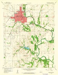
1959 Map of Independence
USGS Topo · Published 1960About this map
The Verdigris River snakes through the eastern half of this Kansas landscape, defining the industrial and recreational character of Montgomery County in the late 1950s. The city of Independence serves as the focal point, showing a dense street grid supporting a multi-tiered education system that includes the High Sch and Jr College, Lincoln Sch, and Washington Sch. On the city's northern edge, Riverside Park and Calvary Cem overlook the river valley, while the local rail economy is evidenced by the crossing of the Atchison Topeka and Santa Fe and Missouri Pacific lines. Further south, the creation of Montgomery County State Park around Coal Creek reflects the mid-century development of public lands. A network of rural country schools, such as Maple Grove Sch and Forty Sch, indicates the enduring structure of the farming community surrounding the main settlement.
Find a feature on this map
40 named features on this map. Tap any name to fly to it.
Don’t see what you’re looking for? This feature index may not catch every label — zoom into the map to look around manually.
Map Details
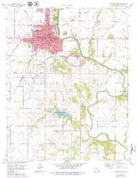
Editions of this 1959 Independence Map
2 editions found
Other maps of this area

1886 · Independence
USGS Topo · 1:125,000

1894 · Independence
USGS Topo · 1:125,000

1905 · Independence
USGS Topo · 1:125,000

1947 · Joplin
USGS Topo · 1:250,000

1949 · Joplin
USGS Topo · 1:250,000

1954 · Joplin
USGS Topo · 1:250,000

1958 · Joplin
USGS Topo · 1:250,000
1959 · Tyro
USGS Topo · 1:24,000

1959 · Joplin
USGS Topo · 1:250,000
1959 · Bolton
USGS Topo · 1:24,000