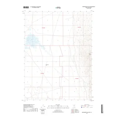
2018 Map of Independence Valley NW
USGS Topo · Published 2018About this map
Ralphs Warm Springs provides a rare point of surface water in this arid stretch of northeastern Nevada, feeding a distinct wetland area on the western floor of Independence Valley. This landscape is defined by the stark transition from the broad, flat valley basin to the rising eastern slopes of the Pequop Mountains. The 2018 survey reveals a terrain largely shaped by natural hydrology and elevation, with the valley floor divided by the section lines of the Public Land Survey System. While human infrastructure is limited to local roads and section boundaries like t36n r64e and t35n r65e, the map documents the essential relationship between geothermal features and the surrounding high desert ecology.
Find a feature on this map
7 named features on this map. Tap any name to fly to it.
Don’t see what you’re looking for? This feature index may not catch every label — zoom into the map to look around manually.
Map Details
Editions of this 2018 Independence Valley NW Map
This is the sole edition of this map. No revisions or reprints were ever made.
Other maps of this area

1955 · Wells
USGS Topo · 1:250,000

1955 · Elko
USGS Topo · 1:250,000

1958 · Wells
USGS Topo · 1:250,000

1958 · Elko
USGS Topo · 1:250,000

1961 · Wells
USGS Topo · 1:250,000

1962 · Elko
USGS Topo · 1:250,000

1965 · Elko
USGS Topo · 1:250,000
1968 · Moor Summit
USGS Topo · 1:24,000
1968 · Independence Valley NE
USGS Topo · 1:24,000
1968 · Independence Valley SW
USGS Topo · 1:24,000