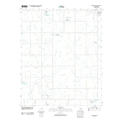
2010 Map of Indiahoma
USGS Topo · Published 2010About this map
Indiahoma sits at the northeastern corner of this Comanche County landscape, a rural hub defined by its grid of section roads and numerous small reservoirs. The map documents a territory shaped by local water management, featuring several unnamed dams and reservoirs like Oknoname 075013 Reservoir and Oknoname 141006 Reservoir. These water bodies are fed by a network of drainage ways including Horse Creek, Jack Creek, and Little Post Oak Creek, which wind through the agricultural plots. For those researching local lineages, the map provides precise locations for three distinct burial grounds: Post Oak Cemetery, the Indiahoma IOOF Cemetery south of town, and Schofield Cemetery in the southern reaches. This modern survey reflects the late 20th-century reliance on Old US Hwy 62 for regional connectivity across the plains.
Find a feature on this map
37 named features on this map. Tap any name to fly to it.
Don’t see what you’re looking for? This feature index may not catch every label — zoom into the map to look around manually.
Map Details
Editions of this 2010 Indiahoma Map
This is the sole edition of this map. No revisions or reprints were ever made.
Other maps of this area

1937 · Cache
USGS Topo · 1:48,000

1937 · Quanah Mountain
USGS Topo · 1:24,000

1942 · Cache
USGS Topo · 1:62,500

1949 · Quanah Mountain
USGS Topo · 1:24,000

1950 · Snyder
USGS Topo · 1:62,500

1955 · Lawton
USGS Topo · 1:250,000

1956 · Post Oak Creek
USGS Topo · 1:24,000

1956 · Odetta
USGS Topo · 1:24,000
1956 · Quanah Mountain
USGS Topo · 1:24,000

1956 · Manitou
USGS Topo · 1:24,000