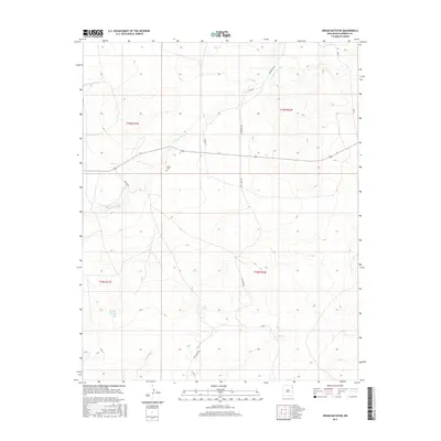
2017 Map of Indian Bathtub
USGS Topo · Published 2017About this map
Cejita Cem sits alone in the open plains of Harding County, marking a quiet point of local heritage in this ranching landscape. The terrain is defined by seasonal watercourses and depressions, most notably the namesake Indian Bathtub and the Arroyo de la Cejita, which winds through the northern sections of the survey. The area is intersected by a network of rural routes, including Culbertson Rd and Hopson Rd, which likely serve isolated homesteads and grazing lands. In the southern portion of the map, the Salt Lakes and Salt Lakes Rd indicate the presence of alkali basins common to this high-altitude region. This 2017 survey by the U.S. Geological Survey preserves the locations of these few scattered landmarks and the original township and range boundaries that organized the settlement of this part of New Mexico.
Find a feature on this map
15 named features on this map. Tap any name to fly to it.
Don’t see what you’re looking for? This feature index may not catch every label — zoom into the map to look around manually.
Map Details
Editions of this 2017 Indian Bathtub Map
This is the sole edition of this map. No revisions or reprints were ever made.
Other maps of this area
1954 · Tucumcari
USGS Topo · 1:250,000
1958 · Tucumcari
USGS Topo · 1:250,000
1966 · Rosebud
USGS Topo · 1:24,000
1966 · Cottonwood Springs
USGS Topo · 1:24,000
1966 · Mc Cloy Ranch
USGS Topo · 1:24,000
1969 · Gallegos NE
USGS Topo · 1:24,000
1969 · Buffalo Springs
USGS Topo · 1:24,000
1973 · Bueyeros NE
USGS Topo · 1:24,000
1973 · Circle Bar Ranch
USGS Topo · 1:24,000
1973 · Indian Bathtub
USGS Topo · 1:24,000