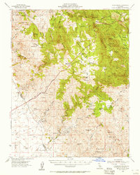
1954 Map of Indian Gulch
USGS Topo · Published 1957About this map
Hornitos City and the historic gold mining districts of the Guadalupe Mountains define this mid-century landscape. The map reveals an intensive history of extraction, with numerous workings like the Saint Marys Mine near Quartz Mtn and the Pocahontas Mine situated in Brushy Canyon. This 1950s record captures the region as water management infrastructure began to reshape the foothills, evidenced by the Mariposa Creek Dam (Spillway 440) and Bear Creek Dam (Spillway 414). Rural life is anchored by local institutions such as White Rock School and the Cathay Fire Control Sta. The terrain transitions from the alluvial plains near LeGrand in the southwest to the high ridges of Schultz Mountain, reflecting the area's dual character as both a ranching frontier and a storied mining territory.
Find a feature on this map
77 named features on this map. Tap any name to fly to it.
Don’t see what you’re looking for? This feature index may not catch every label — zoom into the map to look around manually.
Map Details
Editions of this 1954 Indian Gulch Map
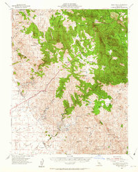
2 editions found
Other maps of this area

1893 · Sonora
USGS Topo · 1:125,000

1896 · Sonora
USGS Topo · 1:125,000

1897 · Sonora
USGS Topo · 1:125,000

1897 · Yosemite
USGS Topo · 1:125,000

1898 · Sonora
USGS Topo · 1:125,000

1900 · Yosemite
USGS Topo · 1:125,000

1903 · Yosemite
USGS Topo · 1:125,000

1909 · Yosemite
USGS Topo · 1:125,000

1912 · Mariposa
USGS Topo · 1:125,000

1915 · Owens Creek
USGS Topo · 1:31,680