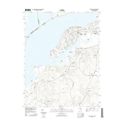
2014 Map of Indian Head
USGS Topo · Published 2014About this map
Indian Head occupies a prominent peninsula on the Potomac River, where the landscape is defined by the deep indentations of Mattawoman Creek and Chicamuxen Creek. This 2014 survey documents the dense residential corridors of Potomac Heights, Warington Hills, and Potomac Wood, which contrast with the more dispersed rural settlements of Pisgah and Doncaster to the south. The proximity to Virginia is marked by the water boundaries of Occquan Bay, while the Maryland interior remains punctuated by numerous local burial grounds including Indian Hill Cem, Marbury Cem, and Alexandria Cem. Along the riverbanks, distinct landforms like Stump Neck, Cornwallis Neck, and Sweden Point provide clear reference points for the transition from maritime navigation to the wooded uplands. The road network, anchored by Indian Head Hwy and Chicamuxen Rd, reveals the continued importance of these historical thoroughfares in connecting the riverside communities.
Find a feature on this map
52 named features on this map. Tap any name to fly to it.
Don’t see what you’re looking for? This feature index may not catch every label — zoom into the map to look around manually.
Map Details
Editions of this 2014 Indian Head Map
This is the sole edition of this map. No revisions or reprints were ever made.
Other maps of this area

1889 · Fredericksburg
USGS Topo · 1:125,000

1890 · Mt. Vernon
USGS Topo · 1:125,000

1891 · Mt. Vernon
USGS Topo · 1:125,000

1892 · Fredericksburg
USGS Topo · 1:125,000

1894 · Fredericksburg
USGS Topo · 1:125,000

1894 · Mt. Vernon
USGS Topo · 1:125,000

1897 · Mt. Vernon
USGS Topo · 1:125,000

1913 · Indian Head
USGS Topo · 1:62,500

1913 · Nanjemoy
USGS Topo · 1:62,500

1923 · Indian Head
USGS Topo · 1:48,000