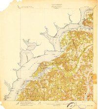
1913 Map of Indian Head
USGS Topo · Published 1913About this map
Naval Proving Grounds and the strategic heights of Fort Washington dominate this shoreline study of the lower Potomac. The landscape is a network of tobacco-era landings and small settlements, where the water remained the primary highway for commerce. Steamboat landings and riverfront commerce are evident at Mattinglys Wharf, Grinders Wharf, and Poseys Wharf, which served the interior tobacco farms of Charles County.
Find a feature on this map
98 named features on this map. Tap any name to fly to it.
Don’t see what you’re looking for? This feature index may not catch every label — zoom into the map to look around manually.
Map Details
Editions of this 1913 Indian Head Map
2 editions found

Other maps of this area

1889 · Fredericksburg
USGS Topo · 1:125,000

1890 · Mt. Vernon
USGS Topo · 1:125,000

1891 · Mt. Vernon
USGS Topo · 1:125,000

1892 · Fredericksburg
USGS Topo · 1:125,000

1892 · Brandywine
USGS Topo · 1:62,500

1894 · Wicomico
USGS Topo · 1:62,500

1894 · Fredericksburg
USGS Topo · 1:125,000

1894 · Mt. Vernon
USGS Topo · 1:125,000

1895 · Wicomico
USGS Topo · 1:62,500

1895 · Brandywine
USGS Topo · 1:62,500