
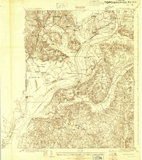
1923 Map of Indian Head
USGS Topo · Published 1923About this map
The Potomac River dominates this early twentieth-century landscape, serving as both a jurisdictional boundary and a vital commercial corridor linked by a designated Steamboat Route. The Maryland side is defined by the industrial and military presence of the Naval Proving Ground and Naval Powder Factory near Indian Head, while the Virginia shore at Mount Vernon and Fort Hunt retains a mix of historical estates and defensive fortifications.
Find a feature on this map
124 named features on this map. Tap any name to fly to it.
Don’t see what you’re looking for? This feature index may not catch every label — zoom into the map to look around manually.
Map Details
Editions of this 1923 Indian Head Map
2 editions found
Other maps of this area

1889 · Fredericksburg
USGS Topo · 1:125,000

1890 · Mt. Vernon
USGS Topo · 1:125,000

1891 · Mt. Vernon
USGS Topo · 1:125,000

1892 · Fredericksburg
USGS Topo · 1:125,000

1892 · Brandywine
USGS Topo · 1:62,500

1894 · Wicomico
USGS Topo · 1:62,500

1894 · Fredericksburg
USGS Topo · 1:125,000

1894 · Mt. Vernon
USGS Topo · 1:125,000

1895 · Wicomico
USGS Topo · 1:62,500

1895 · Brandywine
USGS Topo · 1:62,500