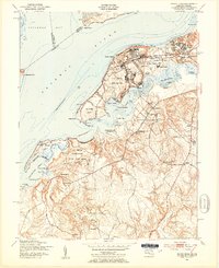
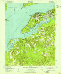
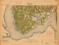
1951 Map of Indian Head
USGS Topo · Published 1954About this map
The US Naval Reservation dominates this 1950s landscape, illustrating the strategic importance of the shoreline where Mattawoman Creek meets the Potomac River. The mid-century development of Indian Head and Potomac Heights is clearly visible, with civilian life and government operations coexisting alongside the US Government railroad line. Local institutions such as Lackey High Sch and St Charles Ch serve these growing communities during a period of significant military and industrial presence.
Find a feature on this map
66 named features on this map. Tap any name to fly to it.
Don’t see what you’re looking for? This feature index may not catch every label — zoom into the map to look around manually.
Map Details
Editions of this 1951 Indian Head Map
2 editions found
Other maps of this area

1889 · Fredericksburg
USGS Topo · 1:125,000

1890 · Mt. Vernon
USGS Topo · 1:125,000

1891 · Mt. Vernon
USGS Topo · 1:125,000

1892 · Fredericksburg
USGS Topo · 1:125,000

1894 · Fredericksburg
USGS Topo · 1:125,000

1894 · Mt. Vernon
USGS Topo · 1:125,000

1897 · Mt. Vernon
USGS Topo · 1:125,000

1913 · Indian Head
USGS Topo · 1:62,500
1913 · Nanjemoy
USGS Topo · 1:62,500

1923 · Indian Head
USGS Topo · 1:48,000