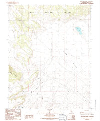
1986 Map of Indian Meadows
USGS Topo · Published 1986About this map
Indian Meadows and the surrounding high-altitude terrain of the Inyo National Forest define this 1980s landscape in Mono County. The map details a transition from the steep eastern slopes of Granite Mountain down into the expansive Adobe Valley. Water management and natural hydrology are central to the area, evidenced by the presence of Adobe Lake and the Adobe Reservoir, which are fed by Adobe Creek and Dexter Creek. The grid-like survey lines cross various landforms including the Adobe Hills and the deep incision of Base Canyon. A lone Corral stands as a rare sign of human utility in this largely undeveloped area, while the convergence of township and range lines highlights the importance of boundary surveying in this part of the Eastern Sierra region.
Find a feature on this map
14 named features on this map. Tap any name to fly to it.
Don’t see what you’re looking for? This feature index may not catch every label — zoom into the map to look around manually.
Map Details
Editions of this 1986 Indian Meadows Map
This is the sole edition of this map. No revisions or reprints were ever made.
Other maps of this area

1909 · Hawthorne
USGS Topo · 1:250,000

1911 · Hawthorne
USGS Topo · 1:250,000

1914 · Mt. Morrison
USGS Topo · 1:125,000

1915 · Hawthorne
USGS Topo · 1:250,000

1947 · Mariposa
USGS Topo · 1:250,000

1948 · Walker Lake
USGS Topo · 1:250,000

1948 · Mariposa
USGS Topo · 1:250,000

1957 · Walker Lake
USGS Topo · 1:250,000

1957 · Mariposa
USGS Topo · 1:250,000

1958 · Trench Canyon
USGS Topo · 1:62,500