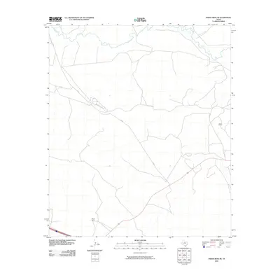
2010 Map of Indian Mesa NE
USGS Topo · Published 2010About this map
The Pecos River meanders across the northern reaches of this West Texas landscape, where the arid terrain is defined by the enduring ranching and energy industries of Pecos County. The Wilson Ranch stands as a focal point for local land history, situated in a region where remote infrastructure like FM 305 and Co-Op Rd provides the primary transit network. Evidence of the Permian Basin's mineral wealth is visible in the east, where the Toborg Oil Field is accessed by the H & P Rd. Smaller waterways such as Fivemile Creek cut through the landscape, feeding into the primary river system. This survey documents the intersection of traditional livestock operations and modern petroleum extraction in a sparsely populated but economically vital portion of the state.
Find a feature on this map
7 named features on this map. Tap any name to fly to it.
Don’t see what you’re looking for? This feature index may not catch every label — zoom into the map to look around manually.
Map Details
Editions of this 2010 Indian Mesa NE Map
This is the sole edition of this map. No revisions or reprints were ever made.
Other maps of this area
1928 · Crane
USGS Topo · 1:125,000
1928 · Rankin
USGS Topo · 1:125,000

1929 · Sheffield
USGS Topo · 1:125,000
1929 · Independence Draw Quadrangle
USGS Topo · 1:125,000

1954 · Pecos
USGS Topo · 1:250,000

1954 · Fort Stockton
USGS Topo · 1:250,000

1954 · Sonora
USGS Topo · 1:250,000

1954 · San Angelo
USGS Topo · 1:250,000

1957 · Pecos
USGS Topo · 1:250,000

1958 · Sonora
USGS Topo · 1:250,000