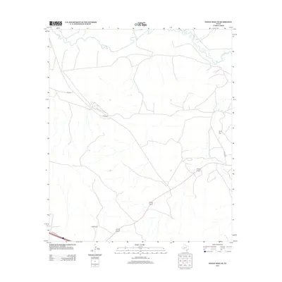
2012 Map of Indian Mesa NE
USGS Topo · Published 2012About this map
The Pecos River snakes across the northern border of this West Texas landscape, marking the rugged transition between the river basin and the high desert plains. In the southern portion of the quadrangle, Wilson Ranch serves as a primary marker of the region’s long-standing ranching tradition. The economy of the land is further defined by the energy sector, specifically at the Toborg Oil Field, where specialized infrastructure like H and P Rd supports petroleum operations. Transport through the arid terrain is facilitated by a network of rural routes including Co Hwy 305 and the smaller Co Op Rd. Water sources are sparse away from the main river, with Fivemile Cr providing one of the few named drainage features in this expansive reach of Pecos County.
Find a feature on this map
8 named features on this map. Tap any name to fly to it.
Don’t see what you’re looking for? This feature index may not catch every label — zoom into the map to look around manually.
Map Details
Editions of this 2012 Indian Mesa NE Map
This is the sole edition of this map. No revisions or reprints were ever made.
Other maps of this area
1928 · Crane
USGS Topo · 1:125,000
1928 · Rankin
USGS Topo · 1:125,000

1929 · Sheffield
USGS Topo · 1:125,000
1929 · Independence Draw Quadrangle
USGS Topo · 1:125,000

1954 · Pecos
USGS Topo · 1:250,000

1954 · Fort Stockton
USGS Topo · 1:250,000

1954 · Sonora
USGS Topo · 1:250,000

1954 · San Angelo
USGS Topo · 1:250,000

1957 · Pecos
USGS Topo · 1:250,000

1958 · Sonora
USGS Topo · 1:250,000