
1951 Map of Indian Mound
USGS Topo · Published 1953About this map
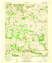
Fort Campbell Military Reservation occupies the northern half of this landscape, its presence marked by an extensive Military Reservation Boundary and numerous ruins where previous homesteads once stood. The southern portion of the quadrangle retains its civilian character, centering on the settlement of Indian Mound and the community at Legate. The terrain is deeply carved by the drainage systems of Cross Creek and Piney Fork, creating a series of ridges where local social life was anchored by institutions such as Rose Valley Ch and Cross Creek Ch. Rural education is well-represented through the locations of the Big A Sch, Atkins Sch, and Commissary Sch, providing a detailed view of the mid-century Stewart County school system. Family history is preserved in several small burial grounds, including the Lineberry Cem and Hall Cem.
Find a feature on this map
32 named features on this map. Tap any name to fly to it.
Don’t see what you’re looking for? This feature index may not catch every label — zoom into the map to look around manually.
Map Details
Editions of this 1951 Indian Mound Map
This is the sole edition of this map. No revisions or reprints were ever made.
Other maps of this area

1931 · Erin
USGS Topo · 1:62,500

1936 · Dover
USGS Topo · 1:24,000

1950 · Dover
USGS Topo · 1:24,000

1951 · Roaring Spring
USGS Topo · 1:24,000

1951 · Johnson Hollow
USGS Topo · 1:24,000

1951 · Bumpus Mills
USGS Topo · 1:24,000

1951 · Herndon
USGS Topo · 1:24,000

1951 · Woodlawn
USGS Topo · 1:24,000

1956 · Nashville
USGS Topo · 1:250,000
1957 · Herndon
USGS Topo · 1:24,000