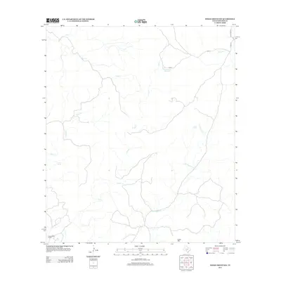
2013 Map of Indian Mountain
USGS Topo · Published 2013About this map
The W Nueces River drainage dominates this section of the Texas Hill Country, where a complex network of seasonal watercourses like Cave Cr and Bluff Cr carve through the limestone plateau. This remote corner of Edwards County is defined by its strategic water sources, most notably the Stagecoach Waterhole and Pecan Springs, which likely served as vital stops in an arid landscape. The topography is anchored by Indian Mtn in the south, overlooking a region where modern ranching infrastructure, such as the Pinon Ranch Airport, exists alongside natural features like Cherry Spring. The road network is sparse, consisting primarily of routes like Co RD-17 and Cedar Creek Rd that follow the natural contours of the various creek branches, including Dry Sycamore Cr and Cherry Cr.
Find a feature on this map
14 named features on this map. Tap any name to fly to it.
Don’t see what you’re looking for? This feature index may not catch every label — zoom into the map to look around manually.
Map Details
Editions of this 2013 Indian Mountain Map
This is the sole edition of this map. No revisions or reprints were ever made.
Other maps of this area
1893 · Nueces
USGS Topo · 1:125,000
1896 · Nueces
USGS Topo · 1:125,000
1944 · Barksdale
USGS Topo · 1:62,500
1944 · Indian Creek
USGS Topo · 1:62,500
1944 · Indian Mountain
USGS Topo · 1:62,500
1947 · Hackberry
USGS Topo · 1:62,500
1958 · Del Rio
USGS Topo · 1:250,000
1964 · Del Rio
USGS Topo · 1:250,000
1967 · Indian Mountain
USGS Topo · 1:24,000
1974 · Twomile Draw
USGS Topo · 1:24,000