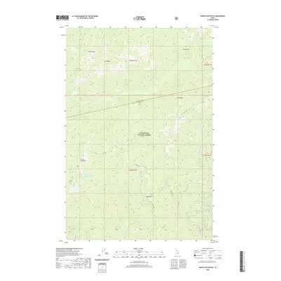
2020 Map of Indian Postoffice
USGS Topo · Published 2020About this map
Indian Postoffice serves as the central landmark for this high-altitude section of the Clearwater National Forest, where the historic Lolo Trl traverses the ridgelines. The landscape is defined by its dramatic relief, spanning the divide between Clearwater and Idaho Counties. This 2020 topographic study illustrates the intricate drainage network feeding into Cayuse Creek and the W Fork Postoffice Cr, with prominent peaks like Spring Mtn and Weasel Point overlooking the surrounding wilderness. The presence of the Indian Postoffice Lake and high-mountain saddles like Deep Saddle highlights the geologic complexity of this remote interior region. Forest access is marked by secondary routes such as Doe Creek Rd and Nat For Dev Rd 565, which navigate the steep terrain between Lunde Ridge and the Rock Garden.
Find a feature on this map
36 named features on this map. Tap any name to fly to it.
Don’t see what you’re looking for? This feature index may not catch every label — zoom into the map to look around manually.
Map Details
Editions of this 2020 Indian Postoffice Map
This is the sole edition of this map. No revisions or reprints were ever made.
Other maps of this area

1911 · Lolo
USGS Topo · 1:250,000

1913 · Lolo
USGS Topo · 1:250,000

1956 · Hamilton
USGS Topo · 1:250,000

1959 · Hamilton
USGS Topo · 1:250,000

1960 · Hamilton
USGS Topo · 1:250,000

1964 · Hamilton
USGS Topo · 1:250,000

1965 · Gorman Hill
USGS Topo · 1:24,000

1965 · Horseshoe Lake
USGS Topo · 1:24,000
1966 · Rhodes Peak
USGS Topo · 1:24,000
1966 · Bear Mountain
USGS Topo · 1:24,000