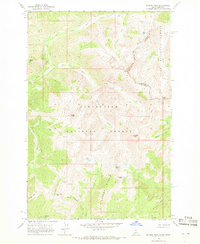
1966 Map of Rhodes Peak
USGS Topo · Published 1968About this map
The Idaho Montana state line defines the high ridgelines of this wilderness region, where the Clearwater National Forest and Lolo National Forest converge. This mid-1960s survey documents a landscape dominated by the Williams Range and significant summits like Rhodes Peak and Williams Peak. Human impact is minimal, primarily represented by a network of Pack Trails used for backcountry navigation. High-altitude hydrology is a central feature, with Smokey Lake, Leo Lake, and Goat Lake feeding into the drainage basins of Kelly Creek and its various forks. Evidence of early prospectors and explorers remains in labels for Mines and a remote Grave near Billy Rhodes Creek, providing rare genealogical and historical anchor points in an otherwise untamed environment. This sheet captures the region's character just before the intensification of modern forest management and recreational mapping.
Find a feature on this map
34 named features on this map. Tap any name to fly to it.
Don’t see what you’re looking for? This feature index may not catch every label — zoom into the map to look around manually.
Map Details
Editions of this 1966 Rhodes Peak Map
2 editions found
Other maps of this area

1911 · Lolo
USGS Topo · 1:250,000

1913 · Lolo
USGS Topo · 1:250,000

1956 · Hamilton
USGS Topo · 1:250,000

1959 · Hamilton
USGS Topo · 1:250,000

1960 · Hamilton
USGS Topo · 1:250,000

1960 · Straight Peak
USGS Topo · 1:62,500

1964 · Hamilton
USGS Topo · 1:250,000

1964 · Rocky Point
USGS Topo · 1:24,000
1964 · White Mountain
USGS Topo · 1:24,000
1964 · Granite Pass
USGS Topo · 1:24,000