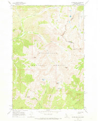
1966 Map of Rhodes Peak
USGS Topo · Published 1973About this map
Rhodes Peak dominates this high-altitude landscape along the border of Idaho and Montana, situated within the expansive Clearwater National Forest and Lolo National Forest. The 1966 field check reveals a terrain defined by the headwaters of North Fork Kelly Creek and its southern branches, where movement is limited to a network of a pack trail and secondary paths. Evidence of early mountain industry and history appears in the southwestern corner, where the Black Lead workings and other mines are located near Blacklead Mtn. A solitary grave and scattered springs near Billy Rhodes Creek hint at the isolated presence of early prospectors or trappers. This survey provides a meticulous record of high-country landmarks like Kellys Finger, Shale Mtn, and the Williams Range before more modern infrastructure altered the backcountry character.
Find a feature on this map
34 named features on this map. Tap any name to fly to it.
Don’t see what you’re looking for? This feature index may not catch every label — zoom into the map to look around manually.
Map Details
Editions of this 1966 Rhodes Peak Map
2 editions found
Other maps of this area

1911 · Lolo
USGS Topo · 1:250,000

1913 · Lolo
USGS Topo · 1:250,000

1956 · Hamilton
USGS Topo · 1:250,000

1959 · Hamilton
USGS Topo · 1:250,000

1960 · Hamilton
USGS Topo · 1:250,000

1960 · Straight Peak
USGS Topo · 1:62,500

1964 · Hamilton
USGS Topo · 1:250,000

1964 · Rocky Point
USGS Topo · 1:24,000
1964 · White Mountain
USGS Topo · 1:24,000
1964 · Granite Pass
USGS Topo · 1:24,000