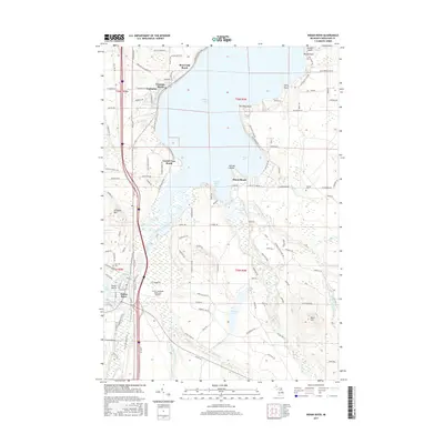
2017 Map of Indian River
USGS Topo · Published 2017About this map
Indian River and the neighboring community of Topinabee serve as the focal points of this 2017 survey, which highlights the inland waterway and lakeshore developments of northern Michigan. The landscape is defined by the massive expanse of Mullett Lake and the southeastern corner of Burt Lake, connected by the winding Indian River. This connectivity shaped the area's growth as a recreational and transit hub, visible in the cluster of waterfront settlements like Giauque Beach, Miami Beach, and Royal Oak Beach. Away from the shore, the terrain rises toward Griswold Mtn and Blats Hill, while several major tributaries including the Pigeon River and Sturgeon River drain the surrounding wetlands. Local history is anchored by the Koehler Cem and Oak Hill Cem, alongside modern infrastructure like the Calvin Campbell Municipal Airport.
Find a feature on this map
128 named features on this map. Tap any name to fly to it.
Don’t see what you’re looking for? This feature index may not catch every label — zoom into the map to look around manually.
Map Details
Editions of this 2017 Indian River Map
This is the sole edition of this map. No revisions or reprints were ever made.
Other maps of this area

1955 · Cheboygan
USGS Topo · 1:250,000

1957 · Tower
USGS Topo · 1:62,500

1957 · Wolverine
USGS Topo · 1:62,500

1957 · Cheboygan
USGS Topo · 1:62,500

1957 · Mullett Lake
USGS Topo · 1:62,500

1958 · Cheboygan
USGS Topo · 1:250,000

1982 · Petoskey
USGS Topo · 1:100,000

1982 · Aloha
USGS Topo · 1:25,000
1982 · Indianville
USGS Topo · 1:25,000
1982 · Mullett Lake
USGS Topo · 1:25,000