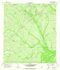
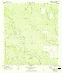
1974 Map of Indian Tank
USGS Topo · Published 1977About this map
The Chittim Gas Field dominates this section of Maverick County, showing a landscape defined by energy extraction and cattle ranching in the mid-1970s. The network of resource management is visible through numerous industrial markers, including a Gas Plant, a Radio Tower, and several dispersed Gas Well and Oil Well sites. This industrial infrastructure is overlaid upon a dry ranching environment where water management is paramount, evidenced by the high density of livestock tanks bearing local family or descriptive names.
Find a feature on this map
23 named features on this map. Tap any name to fly to it.
Don’t see what you’re looking for? This feature index may not catch every label — zoom into the map to look around manually.
Map Details
Editions of this 1974 Indian Tank Map
This is the sole edition of this map. No revisions or reprints were ever made.
Other maps of this area

1940 · Cometa
USGS Topo · 1:62,500

1940 · Eagle Pass
USGS Topo · 1:62,500

1940 · Paloma
USGS Topo · 1:62,500

1940 · Chacon Creek
USGS Topo · 1:62,500

1958 · Eagle Pass
USGS Topo · 1:250,000

1965 · Eagle Pass
USGS Topo · 1:250,000
1974 · Deadmans Hill
USGS Topo · 1:24,000
1974 · Trosado Tank
USGS Topo · 1:24,000
1974 · Sacatosa Tank
USGS Topo · 1:24,000
1974 · Chacon Creek NW
USGS Topo · 1:24,000