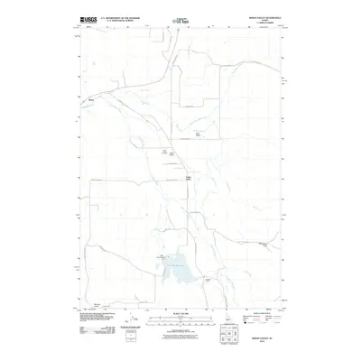
2010 Map of Indian Valley
USGS Topo · Published 2010About this map
Indian Valley serves as the central hub of this agricultural landscape in Adams County, where the Little Weiser River and Grays Creek converge to sustain the local valley floor. The map illustrates a community defined by long-established landmarks and rural infrastructure, including the Indian Valley Cemetery and the Hillsdale School. Significant water management is evident in the south, where the C Ben Ross Dam contains the waters of the Ben Ross Reservoir, a critical feature for the region's hydrology. The settlement of Alpine sits at the western edge of the valley, connected to the core by a network of local roads such as W Indian Valley Rd and Grays Creek Rd. The terrain is marked by distinctive drainages like Ross Gulch, Mundy Gulch, and Tiff Lindsay Draw, which cut through the surrounding hills to join the river system.
Find a feature on this map
32 named features on this map. Tap any name to fly to it.
Don’t see what you’re looking for? This feature index may not catch every label — zoom into the map to look around manually.
Map Details
Editions of this 2010 Indian Valley Map
This is the sole edition of this map. No revisions or reprints were ever made.
Other maps of this area

1894 · Squaw Creek
USGS Topo · 1:125,000

1897 · Weiser
USGS Topo · 1:125,000

1911 · Meadows
USGS Topo · 1:125,000

1954 · Council
USGS Topo · 1:62,500

1955 · Baker
USGS Topo · 1:250,000

1957 · Cambridge
USGS Topo · 1:62,500

1957 · Crane Creek Reservoir
USGS Topo · 1:62,500

1959 · Baker
USGS Topo · 1:250,000

1970 · Granger Butte
USGS Topo · 1:24,000
1970 · Twin Sisters
USGS Topo · 1:24,000