
1983 Map of Indiana
USGS Topo · Published 1983About this map
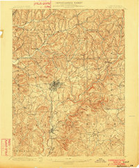
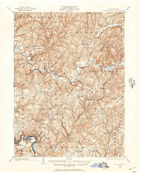
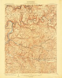
The Allegheny River and Kiskiminetas River anchor this 1983 regional topographic survey, which documents the industrial and academic landscape of Western Pennsylvania during the early 1980s. Centered on Indiana and Butler, the map reveals a dense network of river-town settlements like Ford City, Vandergrift, and Leechburg that define the region's manufacturing heritage. The presence of Indiana University of Pennsylvania and Slippery Rock State College highlights the importance of higher education in these county seats, while local industry is noted at Lucernemines.
Find a feature on this map
267 named features on this map. Tap any name to fly to it.
Don’t see what you’re looking for? This feature index may not catch every label — zoom into the map to look around manually.
Map Details
Editions of this 1983 Indiana Map
This is the sole edition of this map. No revisions or reprints were ever made.
Other maps of this area

1900 · Latrobe
USGS Topo · 1:62,500

1900 · Kittanning
USGS Topo · 1:62,500

1901 · Rural Valley
USGS Topo · 1:62,500

1902 · Kittanning
USGS Topo · 1:62,500

1902 · Latrobe
USGS Topo · 1:62,500
1902 · Indiana
USGS Topo · 1:62,500

1902 · Barnesboro
USGS Topo · 1:62,500
1902 · Elders Ridge
USGS Topo · 1:62,500
1903 · Rural Valley
USGS Topo · 1:62,500

1903 · Latrobe
USGS Topo · 1:62,500