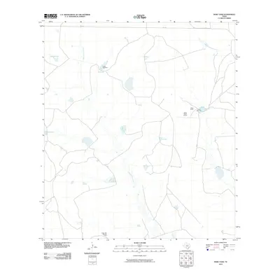
2010 Map of Indio Tank
USGS Topo · Published 2010About this map
San Ambrosia Creek and Rosita San Juan Creek define the arid drainage patterns of this Maverick County ranchland as it appeared in the early 21st century. The landscape is characterized by a sophisticated private water management system essential for South Texas ranching operations, featuring numerous catchments like McFarland Tank, Lopez Tank, and Gialla Tank. The eponymous Indio Tank sits centrally, anchoring a network of unpaved roads and trails that traverse the brush country.
Find a feature on this map
13 named features on this map. Tap any name to fly to it.
Don’t see what you’re looking for? This feature index may not catch every label — zoom into the map to look around manually.
Map Details
Editions of this 2010 Indio Tank Map
This is the sole edition of this map. No revisions or reprints were ever made.
Other maps of this area

1940 · Cometa
USGS Topo · 1:62,500

1940 · Eagle Pass
USGS Topo · 1:62,500

1941 · Botella Creek
USGS Topo · 1:62,500

1957 · Indio Creek
USGS Topo · 1:62,500

1957 · Botella Creek
USGS Topo · 1:62,500

1958 · Eagle Pass
USGS Topo · 1:250,000

1965 · Eagle Pass
USGS Topo · 1:250,000
1982 · Tovar Creek East
USGS Topo · 1:24,000
1982 · Indio Tank
USGS Topo · 1:24,000
1982 · Farias Ranch
USGS Topo · 1:24,000