
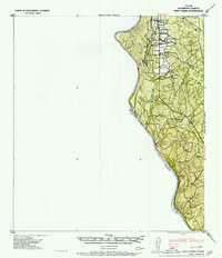
1957 Map of Indio Creek
USGS Topo · Published 1957About this map
Rio Grande frontage and ranching interests define this borderlands survey in Maverick County. The landscape is marked by numerous family-named dwellings and ranch outposts, particularly clustered in the northern reaches where Indio Creek and its namesake Indio Lake are found. Significant landholdings of the Indio Cattle Co suggest a mid-century economy built on livestock, supported by water sources like Cuervo Creek and several unnamed tanks. Small clusters of structures at Cuervo and Tovar are visible in the southern half of the map, while the northern area reveals the individual residences of D H Havin, A Barnes, L Kesling, and E Bradberry. The terrain is characterized by brush and low hills, with the international boundary separating Texas and Coahuila following the river's winding course.
Find a feature on this map
20 named features on this map. Tap any name to fly to it.
Don’t see what you’re looking for? This feature index may not catch every label — zoom into the map to look around manually.
Map Details
Editions of this 1957 Indio Creek Map
2 editions found
Other maps of this area

1940 · Cometa
USGS Topo · 1:62,500

1940 · Eagle Pass
USGS Topo · 1:62,500

1940 · Chupadera
USGS Topo · 1:62,500

1941 · Botella Creek
USGS Topo · 1:62,500

1957 · Botella Creek
USGS Topo · 1:62,500

1958 · Eagle Pass
USGS Topo · 1:250,000

1965 · Eagle Pass
USGS Topo · 1:250,000
1982 · Tovar Creek East
USGS Topo · 1:24,000
1982 · Indio Tank
USGS Topo · 1:24,000
1982 · Farias Ranch
USGS Topo · 1:24,000