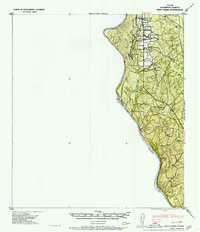
1957 Map of Indio Creek
USGS Topo · Published 1957About this map
The Rio Grande forms a prominent natural boundary between United States and Mexico in this 1940s-era tactical study. The landscape is defined by the ranching economy of Maverick County, notably centered around the Indio Cattle Co and its proximity to Indio Lake. The map reveals a specific pattern of rural habitation, with numerous family-named homesteads including D H Havin, H Melton, and E Bradberry clustered near the northern drainage of Indio Creek. These property labels provide a detailed window into the local genealogy and land use of the mid-20th century. Further south, the terrain transitions toward Tovar and the drainages of Cuervo Creek and Tovar Creek, showing the sparse but intentional distribution of settlements across the brush country of the borderlands.
Find a feature on this map
20 named features on this map. Tap any name to fly to it.
Don’t see what you’re looking for? This feature index may not catch every label — zoom into the map to look around manually.
Map Details
Editions of this 1957 Indio Creek Map
2 editions found
Other maps of this area

1940 · Cometa
USGS Topo · 1:62,500

1940 · Eagle Pass
USGS Topo · 1:62,500

1940 · Chupadera
USGS Topo · 1:62,500

1941 · Botella Creek
USGS Topo · 1:62,500

1957 · Indio Creek
USGS Topo · 1:62,500

1957 · Botella Creek
USGS Topo · 1:62,500

1958 · Eagle Pass
USGS Topo · 1:250,000

1965 · Eagle Pass
USGS Topo · 1:250,000
1982 · Tovar Creek East
USGS Topo · 1:24,000
1982 · Indio Tank
USGS Topo · 1:24,000