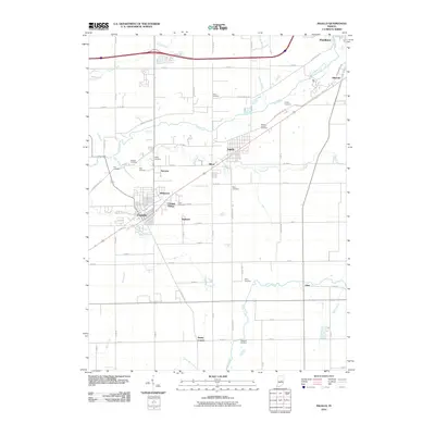
2010 Map of Ingalls
USGS Topo · Published 2010About this map
Fortville and Ingalls serve as the primary hubs in this central Indiana landscape, where the flat terrain is defined by a dense grid of rural roads and the winding paths of several creeks. The area is notable for its high concentration of family and community burial grounds, such as Jones Cemetery, Crosley Cemetery, and Mount Carmel Cemetery, which provide significant anchor points for genealogical research. Smaller residential clusters like Alfont, Sunview, and Helmcrest are interspersed between agricultural fields and the watercourses of Fall Creek and Lick Creek. These settlements illustrate the transition from traditional farming communities to the expanding residential footprint of the early 21st century. Further south, the community of Eden sits near the crossing of Sugar Creek, while numerous drainage features like Wilson Ditch and Jones Ditch show the long-term management of the region's hydrology for productive land use.
Find a feature on this map
78 named features on this map. Tap any name to fly to it.
Don’t see what you’re looking for? This feature index may not catch every label — zoom into the map to look around manually.
Map Details
Editions of this 2010 Ingalls Map
This is the sole edition of this map. No revisions or reprints were ever made.
Other maps of this area

1952 · Cumberland
USGS Topo · 1:24,000

1952 · Greenfield
USGS Topo · 1:24,000

1952 · Ingalls
USGS Topo · 1:24,000

1952 · Mc Cordsville
USGS Topo · 1:24,000

1952 · Anderson
USGS Topo · 1:24,000

1953 · Pendleton
USGS Topo · 1:24,000

1953 · Lapel
USGS Topo · 1:24,000

1953 · Riverwood
USGS Topo · 1:24,000

1953 · Cincinnati
USGS Topo · 1:250,000

1953 · Muncie
USGS Topo · 1:250,000